Why Fire Weather Forecasts Alone Are Not Enough
Every wildfire is driven by three things: fuels, topography, and weather. Emergency managers cannot change the vegetation or the terrain. Weather is the variable that moves, and it often decides how fast a fire spreads and where it goes next.
Unlike a hurricane or a winter storm, wildfire conditions can turn over in minutes. A jump in wind speed, an unexpected shift in wind direction, or a sharp afternoon drop in humidity can push flames into areas that were safe an hour earlier. Forecasts are essential for planning, but they describe expected conditions across a broad area. They cannot tell you that the wind at your incident just backed 40 degrees.
Real-time wildfire monitoring means sensors at the locations that matter, updating continuously, triggering alerts automatically. Forecasts answer what is expected. On-site stations answer what is happening. Emergency managers need both, and the gap between them is where the operational risk lives.
The 0.8-second difference
The common standard for commercial weather services is a five-minute data refresh. Weatherstem updates every 0.8 seconds. During a fast-moving fire run, that gap is operationally significant. An automated alert that fires on live local conditions is fundamentally different from one triggered by data that is already minutes old.
What Emergency Managers Need to Monitor During a Wildfire
Fire weather is a combination of parameters, not a single reading. Each one drives a different operational decision, and the interactions between them matter as much as any value on its own.
Wind is the single most important driver of fire behavior. Gusts push rapid fire runs and carry embers ahead of the line, starting new fires. On-site readings catch changes before forecast updates do.
A modest shift can redirect a smoke plume, threaten a new neighborhood, or invalidate an evacuation zone. Continuous directional data is what tells you whether current protective actions still hold.
Low humidity dries fuels and raises ignition potential. Falling afternoon humidity often coincides with more aggressive fire; overnight recovery can slow it. Local readings flag periods of higher risk.
Fuel moisture sensors read how dry the vegetation actually is at a site, configured into the station where fuels drive the risk picture, as deployed in Jefferson County, Colorado during fire season.
PM2.5 and AQI monitoring track smoke impacts at neighborhood resolution, well beyond the fire itself. Critical for shelter-in-place, evacuation, and public-health messaging decisions.
Lightning is a leading natural cause of wildfires. Dry thunderstorms are the worst case: strikes with little rain. Weatherstem uses NLDN as the primary detection network with AccuWeather as a live backup.
Live cameras close the loop
Every Weatherstem station pairs its sensors with a weatherproof HD camera. During a fire, that means visual confirmation of smoke movement, visibility, and fire growth at remote locations, alongside the numbers. A wind shift on the anemometer plus a plume turning on camera is a far stronger operational signal than either one alone.
Fire Weather Watch vs Red Flag Warning
Two National Weather Service products anchor fire weather planning. They are often confused, but they call for different levels of readiness.
Prepare
Critical fire weather conditions are possible, generally 24 to 96 hours out.
Raise situational awareness, review staffing and evacuation plans, inspect monitoring equipment, brief leadership, and coordinate with fire agencies. A watch is time to get ready.
Be ready to act
Critical fire weather conditions are occurring or expected soon.
Increase staffing and EOC monitoring, coordinate with incident command, step up public messaging, monitor conditions continuously, and support evacuation readiness.
Above the local office level, the Storm Prediction Center issues daily Fire Weather Outlooks that flag where critical conditions are expected, from elevated to critical to extremely critical, plus dedicated dry-thunderstorm categories. These give emergency managers a national view of where fire weather concern is building.
Go deeper on the products
The full breakdown of what each product means, the criteria that trigger them, and how they vary by NWS office is in our companion guide. Read Fire Weather Watches vs Red Flag Warnings.
Case Study: Jefferson County, Colorado
Stations Built for Fuel Moisture from Day One
Jefferson County: Fuel Moisture Monitoring
.jpg)
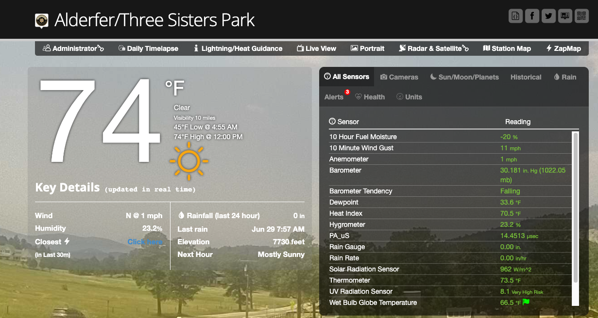
Jefferson County, Colorado operates a network of Weatherstem stations for wildfire situational awareness. Because vegetation conditions are central to the county's fire risk, the stations were deployed with fuel moisture sensors specified as part of the build, reading how dry the fuels actually are at each site. Combined with weather observations and live cameras, that network gives emergency managers and public safety officials a clearer read on fire risk before and during incidents.
Why this matters operationally: the deployment shows how Weatherstem stations are configured to the mission. Where fuels drive the risk picture, fuel moisture sensors are built into the station from the start. The same platform carries different sensor suites for different jobs, matched to exactly what each customer needs to see.
See a live station
Jefferson County stations are publicly viewable, including the fuel moisture data. View the Alderfer station dashboard.
Wind Shifts and the Florida Severe Weather Mesonet
The single most dangerous change in a wildfire is a shift in wind direction. It is also the change a distant forecast is least likely to catch in time. This is where a station standing at the incident earns its place.
The Florida Division of Emergency Management operates one of the largest state-level weather networks in the country, built on Weatherstem with 240+ stations across Florida. During a fire event, the network captured a live wind shift in real time. As Executive Director Kevin Guthrie described it, that observation changed the operational picture and, in his account, helped save responders' lives when the fire progression turned in a completely different direction.
FDEM Executive Director Kevin Guthrie discusses the Florida Severe Weather Mesonet on The Weather Channel.
Ground truth beats regional averages
A wind reading from an airport across the county does not tell you what is happening at the fire line. A directional shift measured on-site, the moment it occurs, is exactly the kind of data that redirects crews and updates evacuation zones before conditions become a headline. For the full FDEM story alongside other government deployments, see the emergency management monitoring guide.
Forecast Data vs On-Site Data
Forecasts and local observations do different jobs. Forecasts anticipate. Stations confirm. During a wildfire, teams that combine both make better calls than teams relying on either alone. Here is how the two compare in practice.
Forecast products remain essential for planning and readiness. A local network complements them by providing ground-truth conditions at the places where wildfire operations actually occur.
Smoke Monitoring and Evacuation Support
Wildfire smoke is a public-health hazard that reaches far beyond the fire. Poor air quality can affect communities miles from any flames, and it can degrade visibility on roadways in ways that create their own emergencies. Weatherstem stations can carry air quality monitors that track PM2.5 at the neighborhood level, alongside the standard weather parameters, so shelter-in-place and messaging decisions rest on local data rather than a distant regional monitor.
The same real-time picture supports evacuation decisions directly. Wind shifts, rising fire intensity, and changing smoke conditions all bear on whether current evacuation zones and traffic plans still make sense. When a station shows conditions changing at an asset, emergency managers can adjust protective actions with confidence rather than waiting on the next forecast cycle.
More in this series
This wildfire cluster is growing. Start with Wildfire Weather Monitoring for Emergency Managers for the full parameter-by-parameter breakdown, then Fire Weather Watches vs Red Flag Warnings. Then, follow those up with how weather data supports evacuation planning. Monitoring wildfire smoke can be just as important as the fire itself with its health risks and impacts to visibility. Finally, be sure to review how EOCs use weather data during wildfires.
Grant Funding for Wildfire Monitoring Equipment
Weather monitoring systems that support life-safety decisions and hazard mitigation are generally eligible for federal grant funding. Wildfire monitoring fits squarely within several programs. Work with your state emergency management agency and FEMA regional office to confirm eligibility for a specific deployment.
Activated after a presidential disaster declaration. Post-fire monitoring network expansions that reduce future losses are commonly funded through HMGP.
Supports core emergency management capabilities. Equipment that enhances situational awareness and operational decision-making during incidents is generally eligible.
State and urban area preparedness grants. Wildfire monitoring infrastructure that supports all-hazards situational awareness may qualify under certain investment justifications.
Working with Weatherstem on grant applications
Weatherstem works directly with emergency management agencies and their grant administrators to provide the documentation, specifications, and pricing information needed for applications. Contact the team early so we can support your submission with the right technical documentation.
What to Look for in a Wildfire Monitoring System
Not every weather system is built for fire operations. Here is what matters when the data is driving life-safety decisions.