Last week, we discussed that the Atlantic Basin would likely set a record for the latest first hurricane of the satellite era. That record was officially broken on September 12, and each day that passes without a hurricane continues to extend it. That said, we are still very much in hurricane season, with more than two months remaining before the season officially ends. There is still plenty of time for tropical development, including the potential for a storm to affect the United States.
New Record Set
A new record for the latest first hurricane in the Atlantic Basin was officially set on September 12. The previous record for the latest first hurricane formation was September 11, set both in 2002 and 2013. This record applies to the satellite era, which began in 1966.
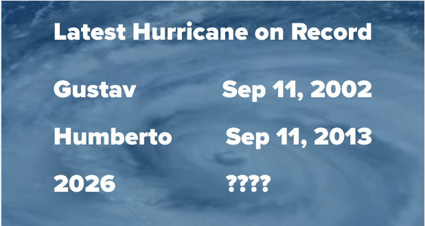
Before the satellite era, 1907 and 1914 went through the entire season without a recorded hurricane. However, tropical systems that formed over the open Atlantic were more likely to go undetected during that era.
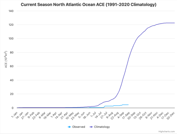
Another way to describe just how quiet this season has been is to look at Accumulated Cyclone Energy (ACE) for the basin. ACE is a metric that accounts for storm intensity and duration, meaning that stronger, longer-lived storms contribute more ACE than weaker, shorter-lived storms. With all five named systems this year being short-lived, Atlantic ACE is currently only 4.4, well below the climatological average for this point in the season. The chart below, courtesy of Colorado State University, shows just how low the value is:
Is There Anything Being Monitored Right Now?
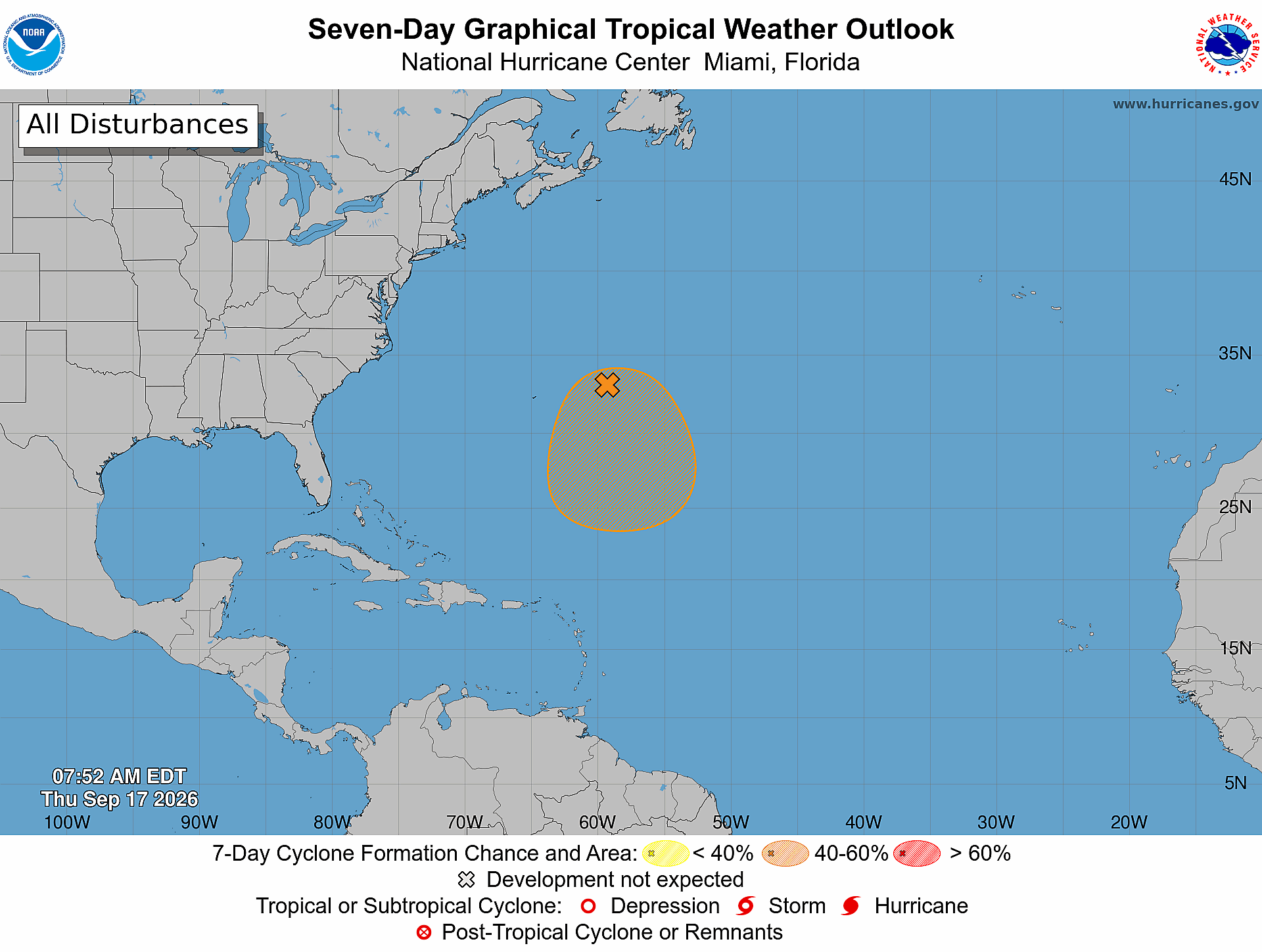
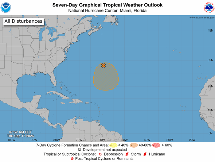
The Atlantic is not completely quiet, however. The National Hurricane Center is currently monitoring one area in the central subtropical Atlantic, with a 40% chance of development over the next seven days.
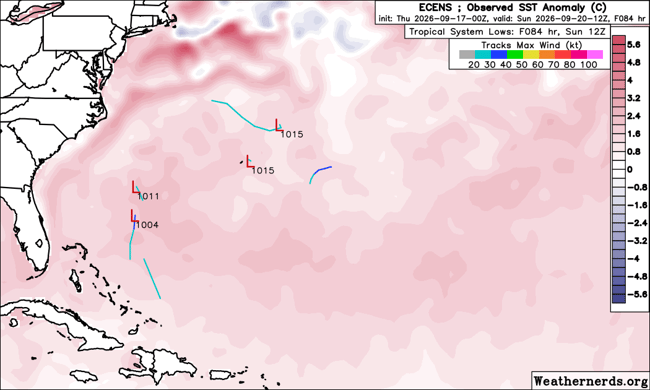
Traditional physics-based models like the Euro and GFS have not been particularly enthusiastic about its development chances, while the Google AI model, which has demonstrated strong performance relative to traditional guidance over the past two hurricane seasons, has been more supportive of development.
Euro Model Valid Sunday September 20th 8 am
Google AI Model Valid Sunday September 20th 8 am
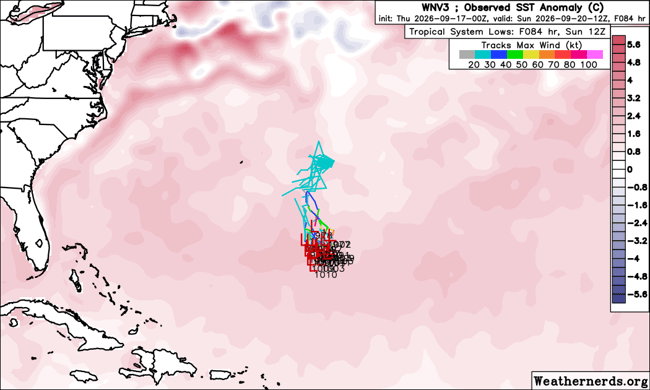 Even if the system develops, current forecast guidance does not suggest a threat to the United States. Bermuda could see some impacts depending on the system's eventual track and development, so interests there should continue to monitor the forecast.
Beyond the current area being monitored, forecast models are also hinting at the possibility of the Central American Gyre (CAG) developing later this month. The CAG is a broad area of storminess around Central America that can sometimes produce tropical systems, both in the Eastern Pacific and in the Gulf and Caribbean. This is an area that is climatologically favored for tropical development this time of year. Note the clustering of origin points in this area in the last 10 days of September and first 10 days of October:
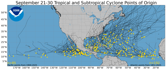
.png?width=700&height=295&name=oct_1_10%20(1).png) While still more than 10 days out, there are some early indications that this area will need to be monitored. Both traditional numerical weather prediction models and AI-based guidance are showing some potential for development. The larger question will be whether any tropical activity that develops remains focused in the Eastern Pacific or shifts toward the Gulf of Mexico and Caribbean.
While still more than 10 days out, there are some early indications that this area will need to be monitored. Both traditional numerical weather prediction models and AI-based guidance are showing some potential for development. The larger question will be whether any tropical activity that develops remains focused in the Eastern Pacific or shifts toward the Gulf of Mexico and Caribbean.
Florida Storm Coverage Increases
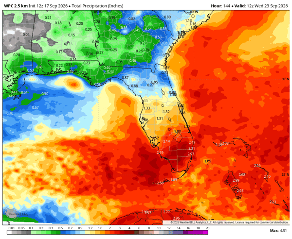
While there is no tropical threat to Florida at this time, a wetter pattern will develop over the coming week as an upper-level disturbance moves across the peninsula. The drought monitor updated today and while conditions have improved since its peak in May, drought still remains across the state:
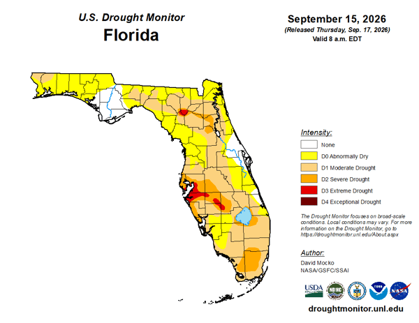
Just two percent of the state is in extreme drought, the lowest amount since January. Still, more rain is needed. Rain totals could be highest across South Florida where 2-3" are possible between now and Wednesday, September 23.
The Season Is Far From Over
The Atlantic has now set a record for the latest first hurricane of the satellite era, but the record does not mean the 2026 hurricane season is over. The climatological peak has passed, but tropical activity typically remains possible through October and into November.
For now, the Atlantic remains unusually quiet, with one area being monitored near Bermuda and some longer-range guidance suggesting that the Central American Gyre could become an area to watch later this month.
We will continue to monitor the tropics and provide updates as areas of interest develop.
What is the record for the latest first hurricane in the Atlantic?
The previous satellite-era record was September 11, set in both 2002 and 2013. The 2026 Atlantic hurricane season surpassed that record on September 12.
Has the Atlantic had a hurricane in 2026?
As of September 17, 2026, no Atlantic tropical cyclone has reached hurricane strength.
Does a late first hurricane mean the rest of the season will be quiet?
Not necessarily. Tropical activity can continue through October and November, and a quiet start does not eliminate the possibility of significant tropical development later in the season.
What is the Central American Gyre?
The Central American Gyre is a broad area of disturbed weather that can develop around Central America and, under favorable conditions, contribute to tropical cyclone development in either the Eastern Pacific or the Gulf of Mexico and Caribbean.
Weatherstem
Real-time weather monitoring for the organizations that can't afford to guess.
Professional hardware, live HD camera, automated alerts, and software — installed and managed for you. 900+ stations deployed nationwide across emergency management, athletics, and commercial operations.
Book a Free Demo
.png)