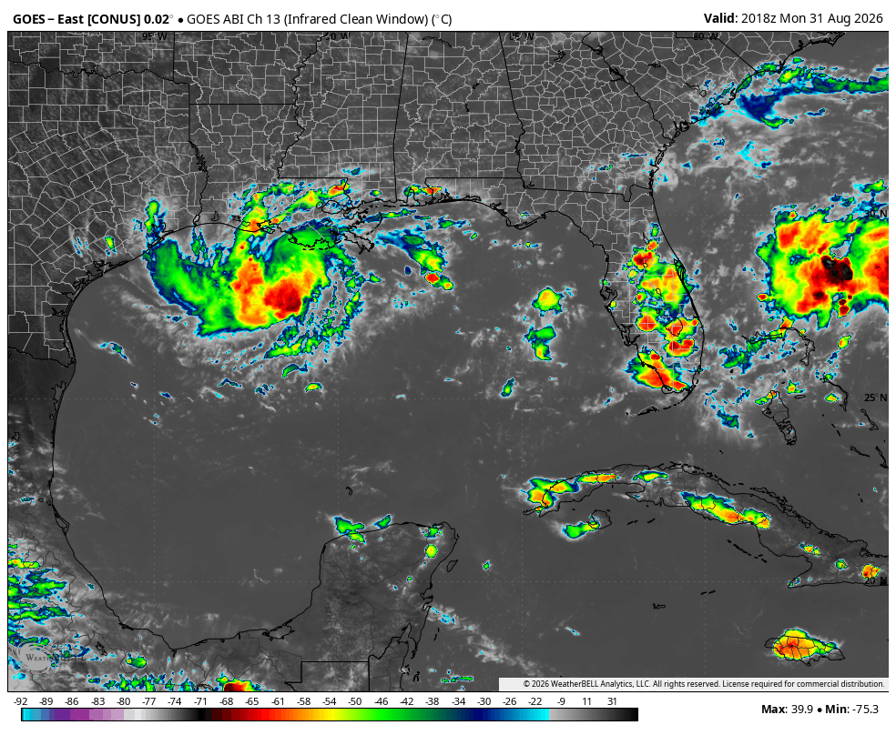
As we approach the peak of the Atlantic Hurricane Season, there are two tropical features worth monitoring for impacts. First, Tropical Depression Five formed earlier today and is expected to become Tropical Storm Edouard before moving ashore along the Texas coast later this week. The second area is the remnants of Tropical Storm Dolly that formed last week. While no longer a tropical system, the moisture could bring enhanced rainfall to the Florida Peninsula for the holiday weekend.
Tropical Depression Five
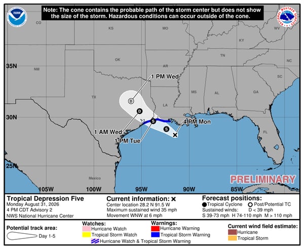
Tropical Depression Five developed on Monday afternoon, becoming the fifth system of the Atlantic Hurricane season. Like we mentioned would be possible in our tropical outlook issued earlier this year, this is yet another system that developed close to the United States. The good news is that it should be short lived and shouldn't strengthen too much before landfall on the Texas coast later on Tuesday. You can see that in the official forecast from the NHC below:
This is consistent with models that indicate only slight strengthening between now and landfall:
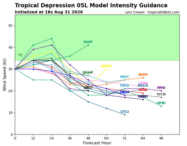 It will be over the warm waters of the Gulf but luckily have limited time to strengthen.
What are the Main Impacts Expected for Tropical Depression Five?
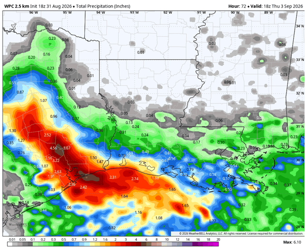
While only limited strengthening is expected before landfall, the system can still produce significant impacts. The primary concern will be heavy rainfall and the potential for flash flooding, particularly across areas that receive the heaviest rain. Below is the rain forecast through Thursday afternoon showing a swatch of 3-5" with locally higher amounts from Houston inland toward College Station:
 The area has been relatively dry recently with drought conditions having increased over the past few weeks. However, even relatively weak tropical systems can produce flash flooding, particularly in an urban area like Houston where heavy rainfall can quickly overwhelm drainage systems. The WPC has highlighted parts of the region for a level two out of four risk for flash flooding on Tuesday and Wednesday.
Tuesday's Flash Flooding Risk :
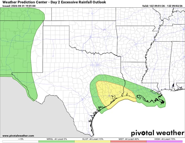 Wednesday's Flash Flooding Risk:
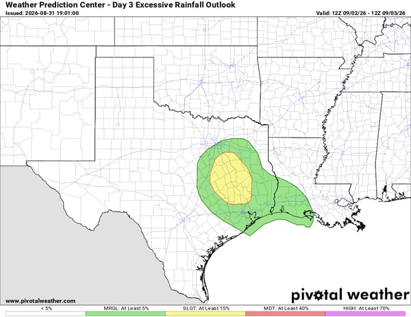 Places that are prone to flooding like low-lying roads should be avoided during travel the next few days.
Farther east, portions of Louisiana could also see periods of heavy rain as moisture associated with the system spreads across the region. The heaviest rainfall is expected closer to the Texas coast, but localized flooding could still develop where heavier thunderstorms persist. Learn how emergency managers can benefit from hyper-local weather monitoring to track impacts during tropical systems here.
Will the Remnants of Dolly Impact the United States?
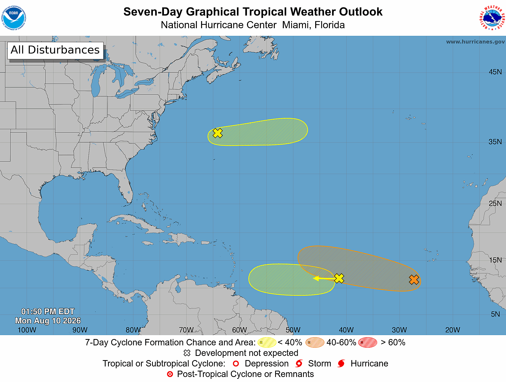
In case you missed it, Tropical Storm Dolly formed in the Main Development Region last week, but only lasted 24 hours before weakening to a tropical wave. You can see the track Dolly took through the Caribbean as a tropical wave by following the dashed line on the map below:
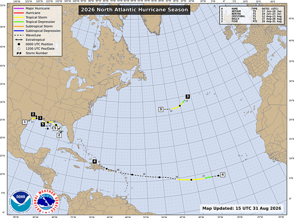 Dolly has been mostly beneficial, bringing much needed rain to Puerto Rico and the Virgin Islands who are experiencing a worsening drought.
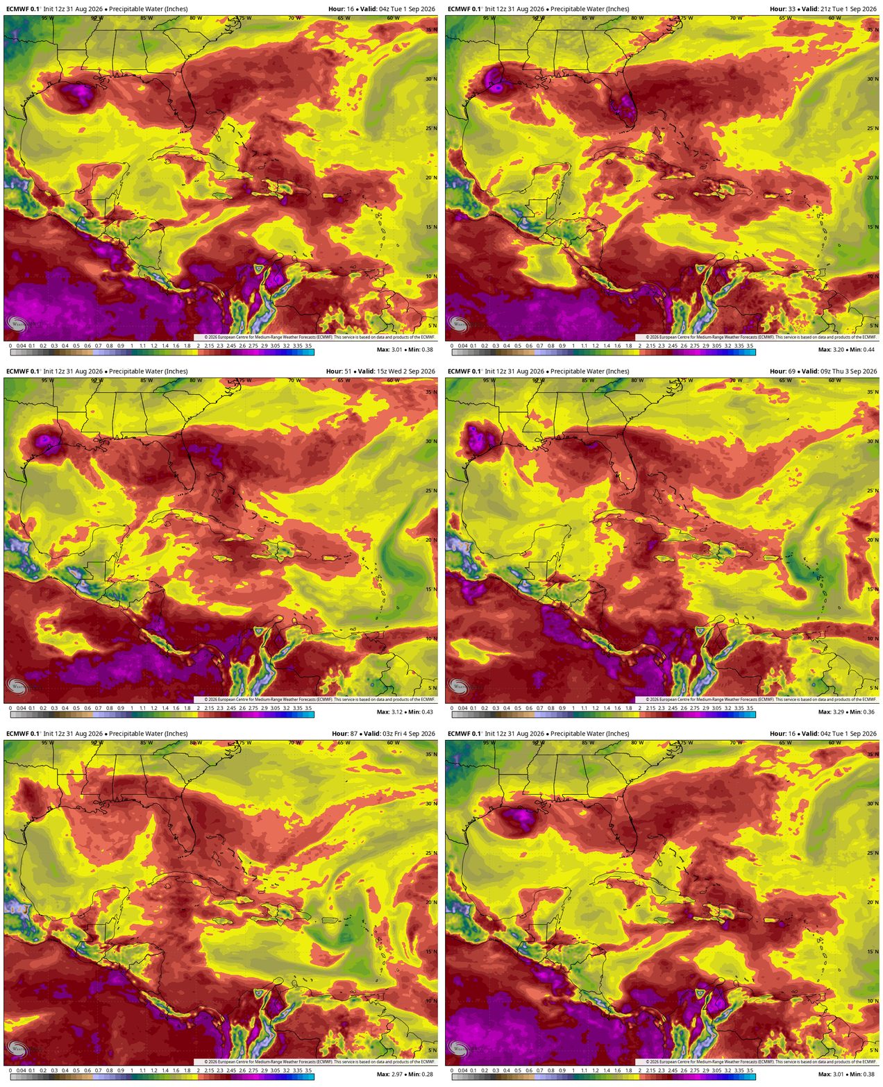
There had been some indication that Dolly could redevelop as it approached the Bahamas and Florida later this week, but those odds have dropped significantly. Instead, the remnants are expected to contribute additional tropical moisture to Florida, increasing rainfall and thunderstorm coverage across the peninsula. Watch as the moisture associated with Dolly moves from Hispaniola to Florida later this week:
 This surge of moisture will reinforce the stormy pattern over Florida and bring beneficial rain to the ongoing drought. Below is the rain forecast through Monday morning, September 7th:
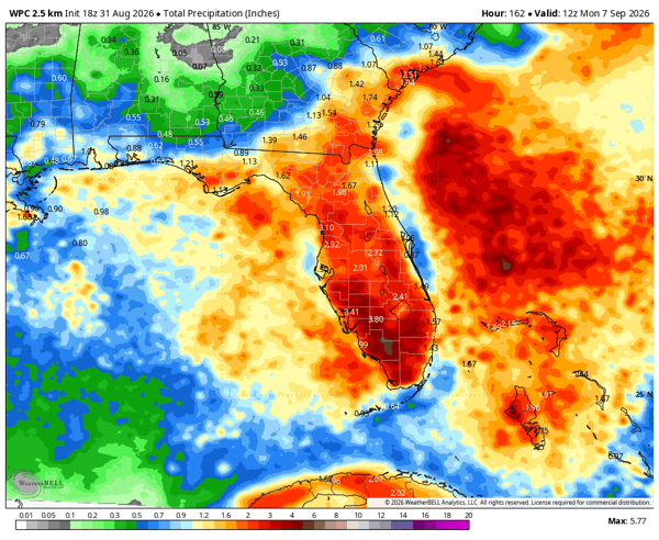 Widespread amounts of two inches are likely which will help relieve the ongoing drought.
Overall, Tropical Depression Five will be the system to watch most closely for immediate impacts, particularly across southeastern Texas and southwestern Louisiana. For Florida, the remnants of Dolly are a much lower-end threat, but the additional tropical moisture could produce several rounds of heavy rain and thunderstorms through the holiday weekend. With drought still affecting portions of the peninsula, much of this rainfall could be beneficial, although locally heavy downpours could still produce temporary flooding.
What is Tropical Depression Five?
Tropical Depression Five is a tropical cyclone in the Gulf of Mexico expected to strengthen before making landfall along the Texas coast.
Will Tropical Depression Five impact Louisiana?
Parts of Louisiana could experience periods of heavy rain as moisture associated with the system spreads east, although the heaviest rainfall is expected closer to the Texas coast.
What are the main threats from Tropical Depression Five?
Heavy rainfall and flash flooding are expected to be the primary concerns, with locally higher rainfall totals possible.
Will Dolly redevelop near Florida?
The likelihood of the remnants of Dolly redeveloping into a tropical cyclone has decreased significantly. However, the remnants can still bring additional tropical moisture, heavy rain and thunderstorms to Florida.
Will Dolly’s remnants help Florida drought conditions?
Yes. Widespread rainfall associated with the remnants could provide beneficial moisture to drought-affected areas of Florida, although locally heavy rainfall could still produce temporary flooding.
Weatherstem
Real-time weather monitoring for the organizations that can't afford to guess.
Professional hardware, live HD camera, automated alerts, and software — installed and managed for you. 900+ stations deployed nationwide across emergency management, athletics, and commercial operations.
Book a Free Demo