We repeatedly discussed the difficulty of the forecast for what has now become Tropical Storm Imelda. There were multiple players in the steering pattern between the trough over the Southeast east, the Bermuda High, and the impressive Hurricane Humberto which became the 2nd category 5 storm of the season on Saturday. The NHC forecast trend below is very impressive with a hard right turn now expected: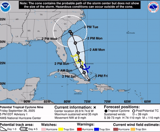
Ultimately, the slower development pace and forward motion of Imelda will allow it to be pulled east by Humberto, preventing a landfall in the US. After last year's catastrophic Hurricane Season, we could all use a break from landfalling systems.
Imelda has been pounding the Bahamas today with heavy rain and gusty winds. Take a look at our camera on Blue Lagoon Island today where winds have gusted as high as 46 mph and it is definitely not a day to be on the water.
The elevated surf, rip currents and potential coastal flooding will be worth monitoring across the southeast through the week. For a refresher on the dangers of marine hazards, refresh your memory by reading through the Weatherstem module on these hazards. These impacts will last through much of the week as you can see in the below animation:
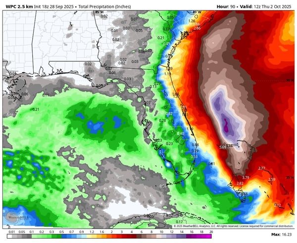
 Rain will also still be heavy at times, especially right along the coast. 1-2" are expected along the Florida coast in addition to 2-3" along the GA, SC, and NC coasts with locally higher amounts:
 For now, we breathe a sigh of relief but keep monitoring the forecast, not only for Imelda but for the rest of the Atlantic. There are still over 2 months left in the season.
Weatherstem
Real-time weather monitoring for the organizations that can't afford to guess.
Professional hardware, live HD camera, automated alerts, and software — installed and managed for you. 900+ stations deployed nationwide across emergency management, athletics, and commercial operations.
Book a Free Demo

