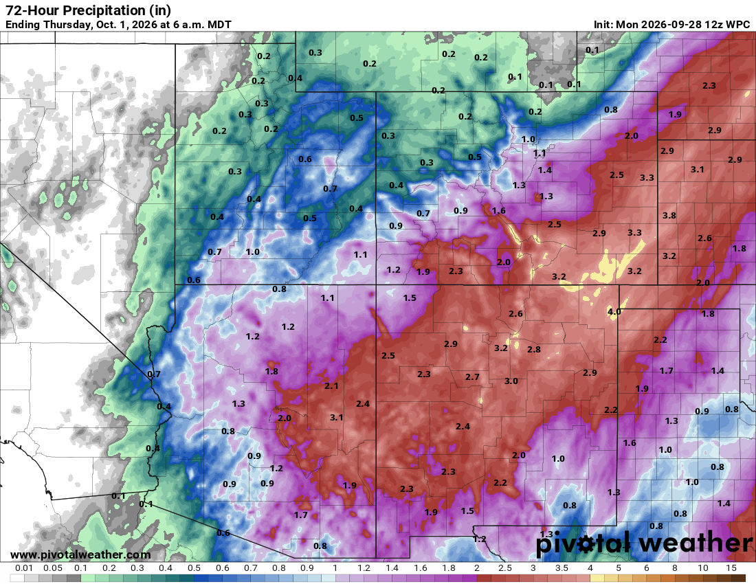
As we mentioned in our hurricane season outlook earlier this year, the Eastern Pacific has been extremely active, with 18 named storms forming already this year. Hurricane Polo, which reached Category 5 status multiple times, is expected to make landfall on the Baja Peninsula later Monday evening as a major hurricane. Moisture from the system will stream into the Southwest and eventually the Central U.S., leading to a multi-day flood threat across the region.
 Southwest Flood Threat
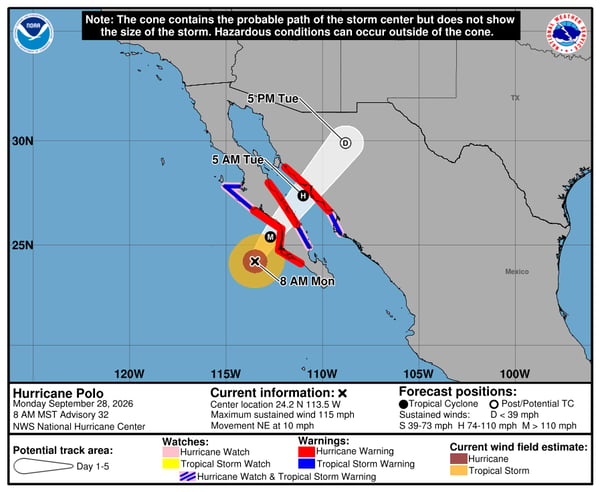
The flood threat across the Southwest will ramp up on Monday and continue into midweek. Monday and Tuesday both have a level three out of four flood threat across the region:
Monday's Flood Threat:
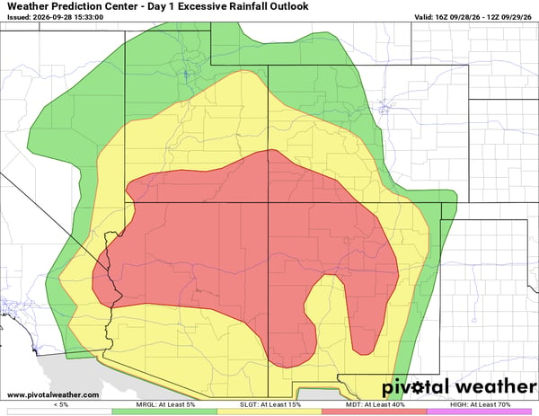 Tuesday's Flood Threat:
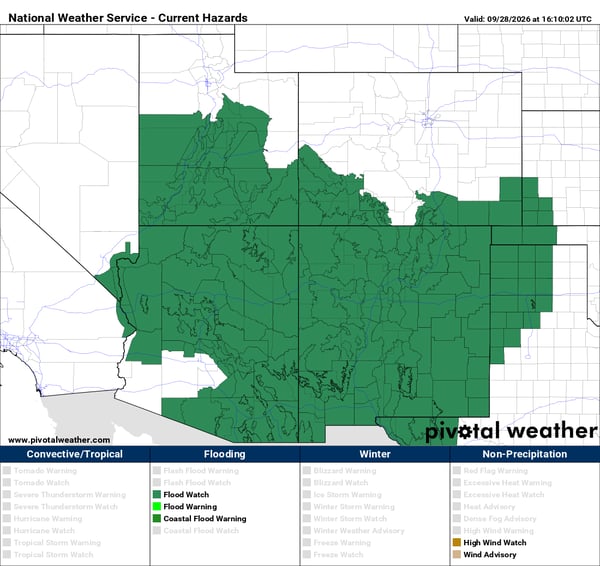
 Not surprisingly, there's a flood watch up for much of the region:
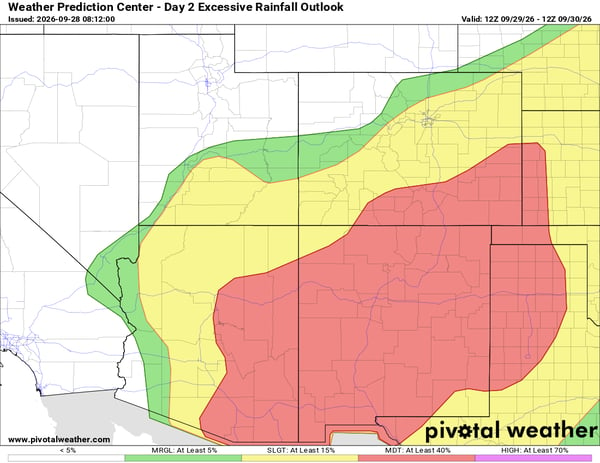
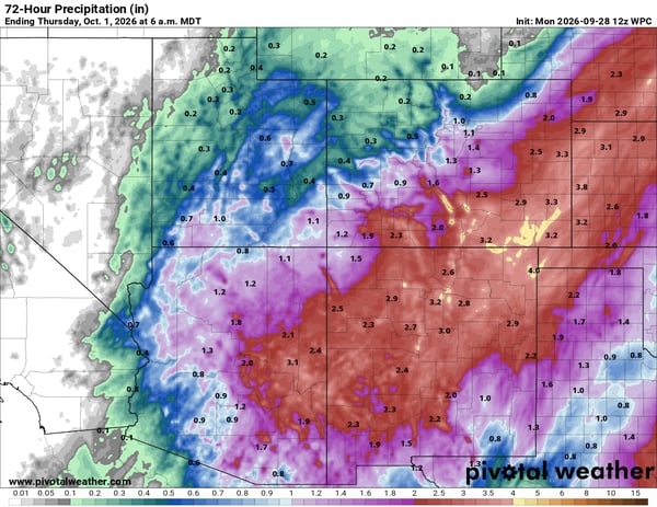
 Rain totals over the area will range from 1-3" with locally higher amounts possible through Wednesday:
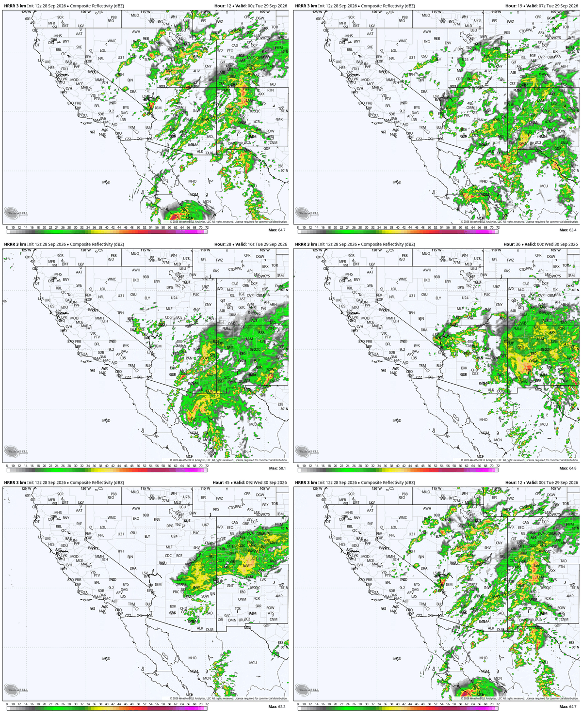
In the animated future radar below, you can get a general idea of timing as it shows Monday evening through early Wednesday morning:
 Flash flooding can be particularly dangerous in the Southwest, where intense rainfall can quickly produce runoff across steep terrain, normally dry washes and arroyos, and areas with recently burned landscapes.
Heavy Rain Spreads to Central U.S.
By Wednesday, moisture from the remnants of Hurricane Polo will spread farther east and interact with an upper-level trough moving into the Plains. This will lead to a multi-day flood threat across the Central U.S., starting with a level 3 out of 4 flood risk on Wednesday that includes parts of Southeast Colorado and the Dallas Metro area:
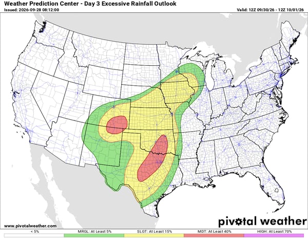 The heavy rain and flood threat extends all the way to the Midwest. By Thursday, the Dallas area is still under a level 3 out of 4 flood risk:
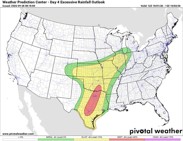
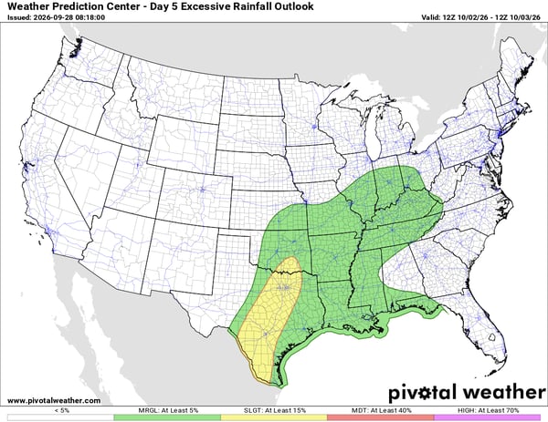
The heavy rain threat will continue over parts of Central Texas into Friday, but the risk level does drop to a two out of four:
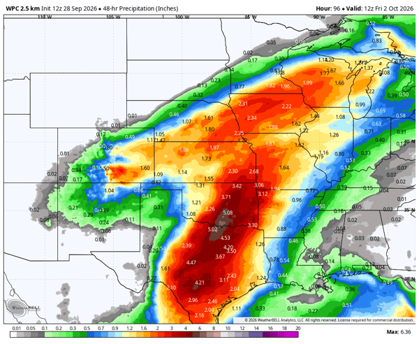
Rain totals across the area from Wednesday morning to Friday morning show a bullseye of 3-5" across the I-35 corridor from Dallas to Oklahoma City:
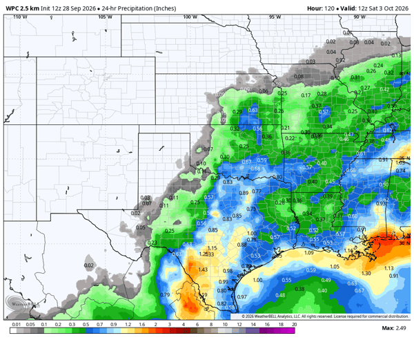
 From Friday morning to Saturday morning another 1-2" of rain is possible across the Southern Plains:
 While drought conditions have increased across parts of the region recently, heavy rainfall over a short period can still produce significant runoff and flooding.
Other Tropical Activity to Monitor
The Eastern Pacific remains active, with Tropical Storm Rachel now south of Mexico and forecast to track toward the Baja Peninsula later this week.
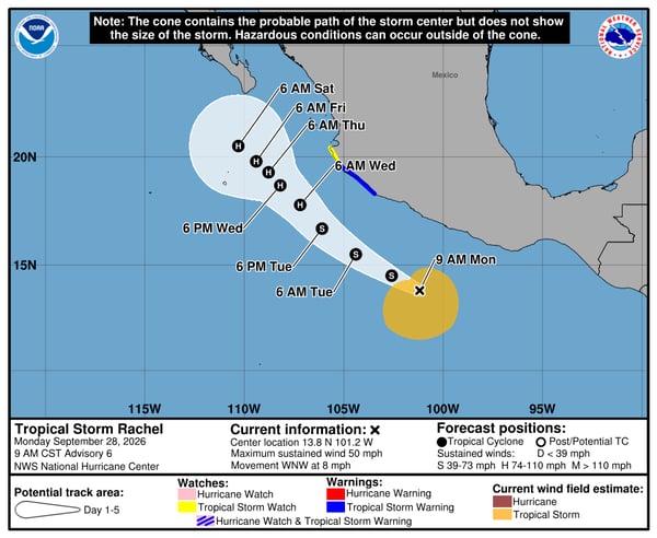 While current forecasts keep Rachel offshore, it is worth monitoring as the week progresses.
In the Atlantic, Tropical Storm Hanna formed Monday but is currently forecast to remain well away from land.
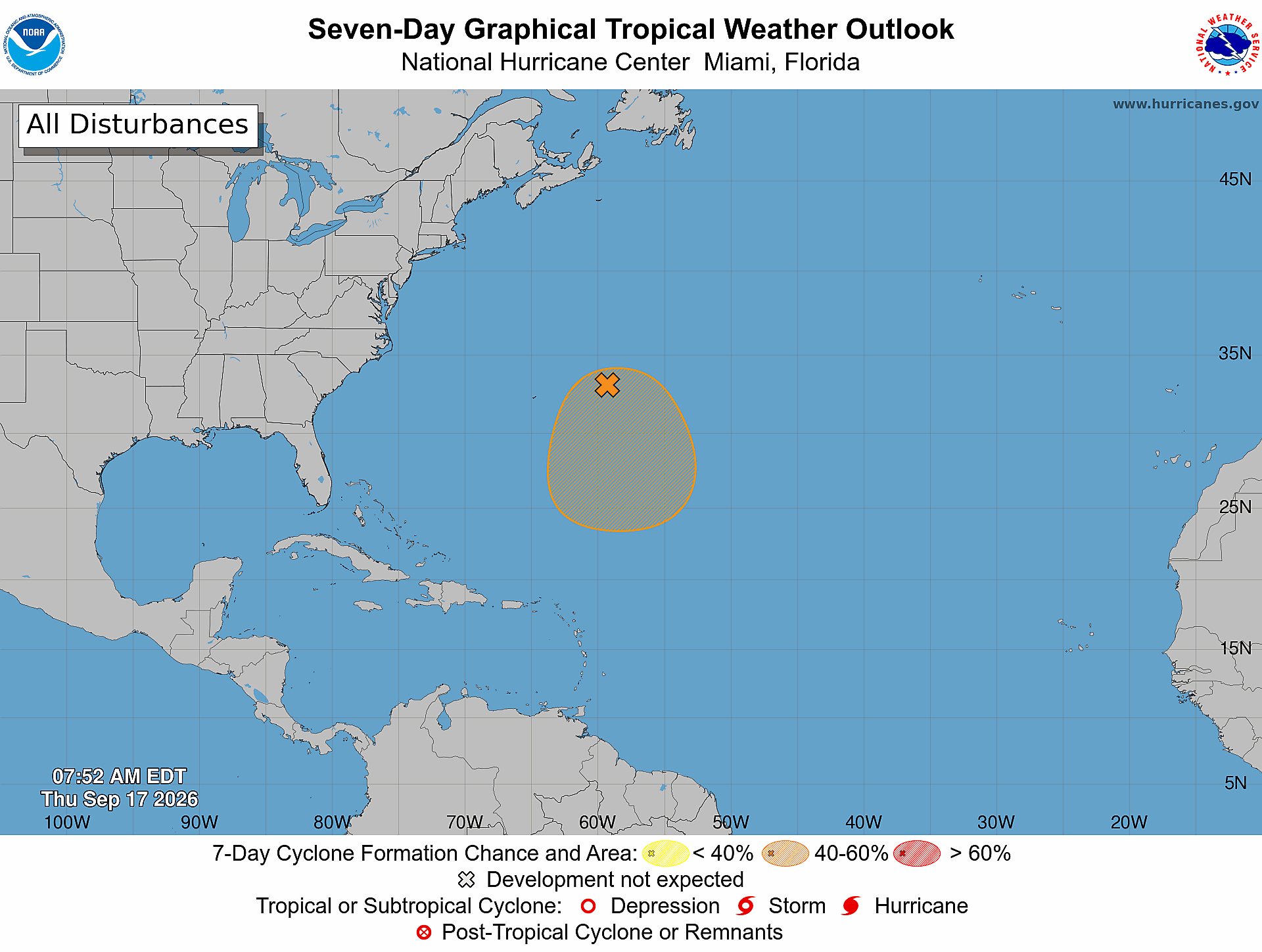
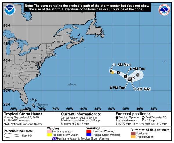 The Atlantic basin continues to set records for the quietest year and still hasn't produced a hurricane. There are some indications that the Gulf could become an area to monitor toward the end of the first week of October, although it is still too early to determine whether tropical development will occur.
What areas are at risk for flooding from Hurricane Polo's moisture?
Moisture from Hurricane Polo is expected to contribute to a multi-day flood threat across portions of the Southwest, including areas of Arizona, New Mexico, Utah and Colorado. The threat will then spread eastward into parts of the Central U.S.
How much rain is expected in the Southwest?
Rainfall totals of 1 to 3 inches are possible across portions of the Southwest through Wednesday, with locally higher amounts possible.
Why can heavy rain cause flooding in the Southwest?
Intense rainfall can quickly produce runoff across steep terrain, normally dry washes and arroyos, and areas affected by recent wildfires. Heavy rainfall rates can overwhelm drainage capacity and lead to flash flooding.
Will Hurricane Polo's moisture affect areas outside the Southwest?
Yes. Moisture from the remnants of Polo is expected to spread eastward and interact with an upper-level trough, contributing to a multi-day heavy rain and flood threat across portions of the Central U.S.
How long will the flood threat continue?
The Southwest flood threat is expected to increase Monday and Tuesday and continue into midweek. The heavy rain threat will then shift eastward, with portions of the Central U.S. potentially remaining at risk through Friday and beyond.
Weatherstem
Real-time weather monitoring for the organizations that can't afford to guess.
Professional hardware, live HD camera, automated alerts, and software — installed and managed for you. 900+ stations deployed nationwide across emergency management, athletics, and commercial operations.
Book a Free Demo
.png)