Florida Drought Update: How Have Conditions Improved?
Thanks to a rainy pattern the past few weeks, there has been significant improvement in the drought across Florida. At the start of May, 25% of the state was in exceptional drought:

According to the U.S. Drought Monitor, exceptional drought is the most severe drought category and indicates widespread impacts on water resources, agriculture, and wildfire risk. In the latest update, that number has dropped to just 10%

This is a great improvement but there's still a long way to go. Luckily the rainy season has just begun and the weeks and months ahead should bring more improvements.
Why Has Florida Received So Much Rain Recently?
You can see why there has been such an improvement in the drought monitor by looking at the past 30-day rainfall below:
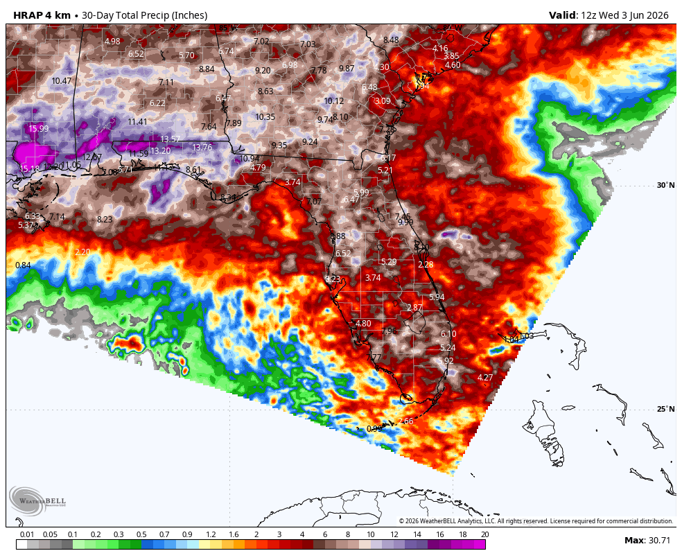
Parts of the Florida panhandle received over a foot of rain. Most of this rain fell over the past two weeks. This was due to the start of the rainy season and an increase in sea breeze activity combined with a persistent flow of moisture over the state.
When Will Florida's Rainy Season Return?
This rainy pattern is going to take a pause for the next week or so as a drier air mass settles in. Watch the below animation of the precipitable water anomaly showing a drier air mass over much of the Florida Peninsula into next week. The blues and greens show air that is much drier than typical this time of year:
 Not surprisingly, the accompanying rain forecast for the next 7 days is well-below average for most of Florida except the extreme southern part:
<Forecast graphic previously posted here is no longer available>
Could Tropical Development Increase Florida Rainfall?
After a pause in storm activity for the next week, a wetter pattern will return to Florida and the rest of the Southeast. This pattern could even bring a tropical threat in the middle of the month. Below is the 7 day rainfall from June 11-June 18th:
<Forecast graphic previously posted here is no longer available>
It shows above-average rainfall expected across Florida and much of the Southeast. If this forecast verifies, additional drought improvement is likely across Florida and neighboring states. The Florida rainy season is now underway, and despite a brief pause in rainfall, conditions remain favorable for additional drought improvement through June.
From drought monitoring to tropical weather tracking, Weatherstem gives emergency managers and operations teams real-time weather intelligence to stay ahead of changing conditions. Contact Weatherstem to learn how real-time weather monitoring can support your organization.
What is the Central American Gyre?
There are also signals that a tropical system could emerge into the Gulf. Below are the ECMWF ensemble members showing that potential for Sunday, June 14th:
 Google's AI weather model, WeatherNext, which performed well during the 2025 hurricane season, is also beginning to indicate the potential for development during the same period
 When independent forecast systems begin highlighting the same area for potential development, it can increase confidence that the pattern is worth monitoring, even if confidence in tropical formation remains low. However, this time of year tropical development does tend to occur close to the US with the Gulf and Southeast Coast being the likely spots. Below are the points of origin for tropical systems June 11 - 20:
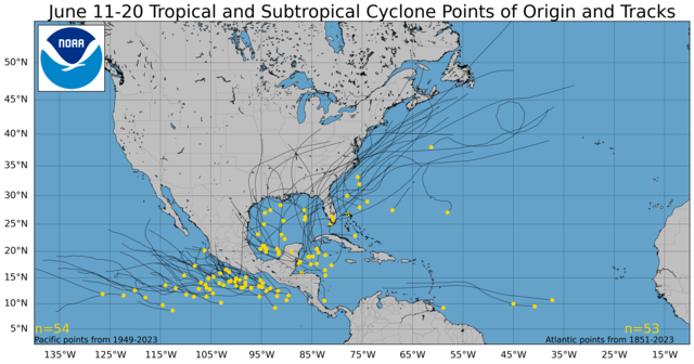
This is due to the Central American Gyre (CAG) being most active early and late in the tropical season. The CAG is a broad area of low pressure that occurs over the eastern Pacific Ocean and western Caribbean Sea. The CAG often produces tropical systems, both in the Eastern Pacific and in the Caribbean or the Gulf. So the fact that models are suggesting the possibility of a tropical system developing isn't unusual and it's something to monitor the next 7-14 days. For now, the improving drought picture remains the main story, but tropical development will be worth watching as the Florida rainy season continues through June.
Has Florida's drought improved in 2026?
Yes. Exceptional drought coverage has decreased from 25% of the state in early May to approximately 10% thanks to several weeks of widespread rainfall.
Why has Florida been wetter than normal recently?
The start of the rainy season, enhanced sea breeze activity, and persistent moisture have produced above-average rainfall across much of the state.
Could a tropical system develop near Florida in June?
Forecast models show a small possibility of tropical development in the Gulf of Mexico during mid-June, though confidence remains low this far in advance.
What is the Central American Gyre?
The Central American Gyre is a broad area of low pressure that develops over the western Caribbean and eastern Pacific and can help spawn tropical systems in the Gulf and Caribbean Sea.
Weatherstem
Real-time weather monitoring for the organizations that can't afford to guess.
Professional hardware, live HD camera, automated alerts, and software — installed and managed for you. 900+ stations deployed nationwide across emergency management, athletics, and commercial operations.
Book a Free Demo

