Introduction
Several weather stories are worth monitoring as June transitions into July. Florida’s rainy season continues to bring drought relief, but rainfall has been uneven across the state. At the same time, severe weather remains active across parts of the Midwest, and the biggest story heading into the Fourth of July holiday will be an expanding heat wave across much of the United States.
Florida Rainy Season and Drought Conditions Update
When June began, Florida was coming off significant drought improvement, with approximately 25% of the state in exceptional drought at the start of May. By early June, that number had dropped to around 10 percent.

With the latest update, exceptional drought has been eliminated, and nearly 5 percent of the state is now drought free.

This improvement was supported in part by Tropical Storm Arthur, which brought widespread rainfall to portions of the western Florida Panhandle. In the below image, you can see the heavy rain that fell in the Panhandle from June 16 to June 23:
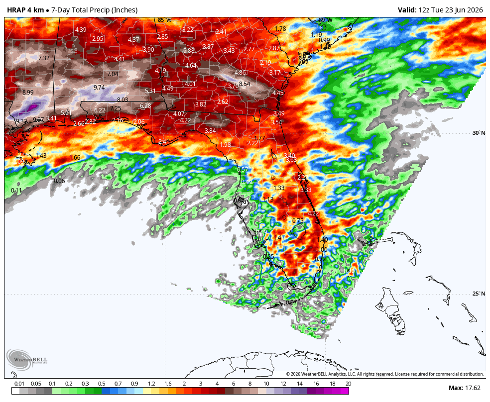
Unfortunately, places like the Tampa Bay area and interior South Florida received very little rain and are still in the extreme drought category. In fact, there are still several wildfires burning across South Florida. Watch this timelapse from June 24th that shows wildfire smoke followed by a strong summer thunderstorm that dropped over 2" of rain:
Rainfall Outlook for Late June into Early July
As June winds down and we head to July, average monthly rainfall typically goes down. Take a look at Miami as an example:

June averages over 10 inches of rain in Miami, while July drops closer to just over 7 inches. Rainfall remains frequent, but totals typically decrease compared to early summer peak values. That said, the next two weeks do look to have below average rainfall as June ends and July begins. Below is the rainfall anomaly from June 25 - July 10:
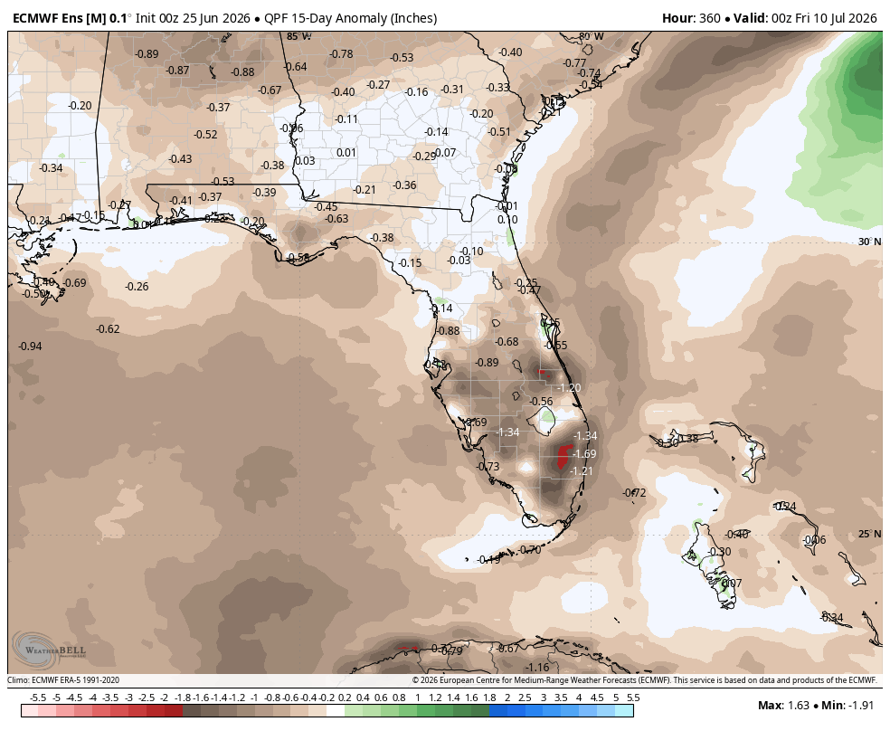 This doesn't mean no rain will fall, just less than what is normal this time of year.
Tropical Development Signal Near the Southeast
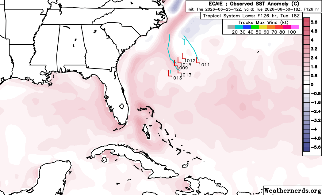
As we saw last week with Tropical Storm Arthur, weak tropical systems can be beneficial in bringing soaking rains to drought-stricken areas. There is a small chance that another tropical system develops close to home in the beginning of July. We've mentioned the successful performance of AI models in predicting tropical development and once again, they are indicating possible development off the Southeast coast for early July. The Euro AI model shows the potential for June 30th:
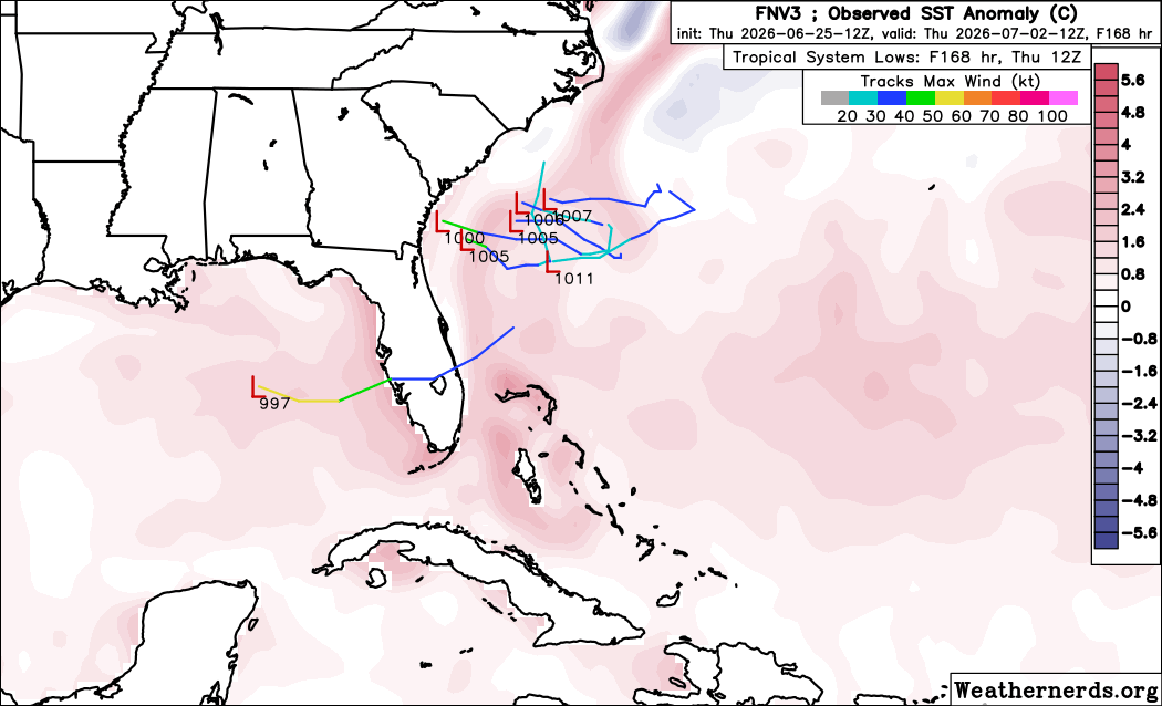
 While the Google Al model is a bit more aggressive and later with development:
The odds of development are low for now but they were low for Tropical Storm Arthur too and it is worth monitoring in the days ahead.
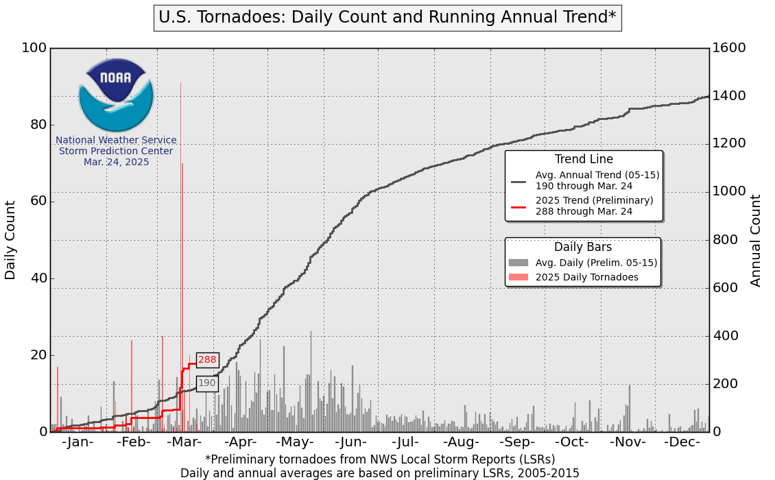
Active June Severe Weather Pattern Continues
June has been an active month for severe weather, especially across parts of the Midwest and the Ohio Valley, including Illinois. After starting the month below average for tornado activity, totals have quickly climbed to above average levels for the year.
More severe weather is likely to end the month of June, starting with another risk across parts of Illinois for Friday, June 26:
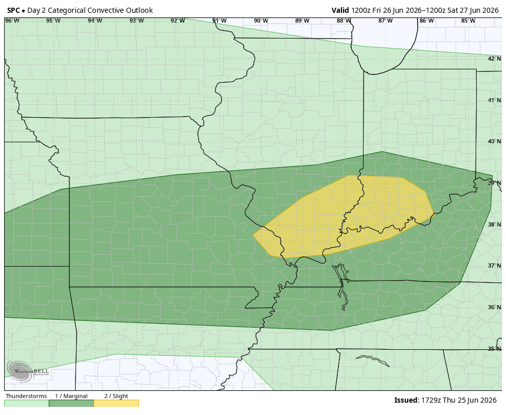
This round of severe weather will bring the threat of tornadoes and damaging winds.
Heat Wave Builds Ahead of the Fourth of July Holiday
The Climate Prediction Center continues to show a high likelihood of above-average temperatures across much of the eastern United States to start July:

This pattern is being driven by a strong upper-level ridge building across the region. If it verifies, the heat is expected to persist through the Fourth of July holiday weekend.

With numerous outdoor events planned for America’s 250th anniversary celebrations, this setup will have important public safety and operational implications, particularly for heat stress, hydration planning, and event management.
FAQ: Fourth of July Weather Outlook, Florida Rainy Season, and U.S. Heat Wave
Is Florida’s rainy season still helping reduce drought conditions?
Yes, but the improvement has been uneven. Some areas, particularly the Florida Panhandle, have seen meaningful rainfall and drought reduction. However, parts of South Florida and the Tampa Bay region remain drier than normal and are still experiencing drought conditions.
Why is Florida rainfall decreasing in late June and early July?
Rainfall typically decreases slightly as Florida moves from the peak of its early summer rainy season into July. While daily thunderstorms remain common, overall monthly totals tend to be lower compared to June.
Are tropical systems still possible near Florida in early July?
There is a low but non-zero chance of tropical development near the Southeast U.S. early in July. Most model guidance does not show strong organization at this time, but weak systems in this pattern can occasionally enhance rainfall across Florida even if they remain disorganized.
How strong will the Fourth of July heat wave be?
Forecast guidance indicates a strong ridge of high pressure building across much of the eastern United States. If this pattern verifies, it will support above-average temperatures and periods of dangerous heat across a large portion of the country during the holiday weekend.
What are the main risks from the upcoming heat wave?
The primary concerns include heat stress, dehydration, and increased strain on outdoor activities and public events. High humidity may also contribute to elevated heat index values, increasing the risk for heat-related illness.
Will the heat wave affect outdoor Fourth of July events?
Yes. Many outdoor events across the eastern U.S. may be impacted by high temperatures and humidity. Event planners and emergency managers should monitor forecasts closely and prepare for heat mitigation strategies such as cooling stations, hydration access, and schedule adjustments.
How long will the heat wave last?
Current guidance suggests the heat pattern may persist beyond the Fourth of July weekend, although exact duration will depend on how long the upper-level ridge remains in place.
Weatherstem
Real-time weather monitoring for the organizations that can't afford to guess.
Professional hardware, live HD camera, automated alerts, and software — installed and managed for you. 900+ stations deployed nationwide across emergency management, athletics, and commercial operations.
Book a Free Demo

