
Several weather stories are developing across the U.S. this week that require emergency managers to monitor multiple hazards. Severe weather will continue from the Midwest into the Northeast through the end of the work week, while Florida's rainy season is beginning to reestablish itself after a recent dry stretch. Meanwhile, forecasters are watching the Bay of Campeche, where there is a low chance for tropical development later this weekend. Here's a breakdown of the active weather patterns we're tracking.
Severe Weather Threat Continues Into the Weekend
This week has already been an active week of severe weather. On Monday, there were over 180 reports of severe weather, most of which were damaging winds:

In fact, there were several reports of wind gusts over 100 mph in the Salina, KS area. The severe weather continued on Tuesday with nearly 300 reports of severe weather once again dominated by damaging winds:

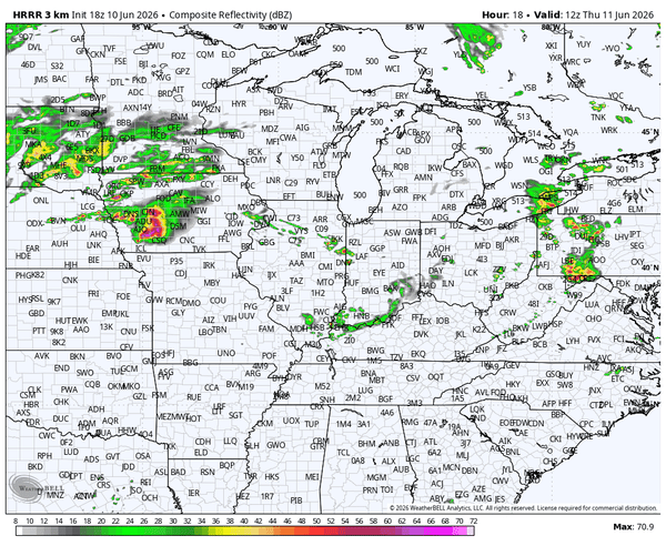
Multiple Rounds of Severe Weather for the Midwest and Great Lakes
Storms are ongoing as of this blog post across the Midwest but additional storms are likely later this evening and through the overnight hours. A level 3 out of 5 threat is in place for damaging winds, large hail, and a few strong tornadoes:
<Forecast graphic previously posted here is no longer available>
Watch the storms continue into the overnight and early morning hours in the future radar animation below that is valid from Wednesday 5 pm CDT to Thursday 7 am CDT:
 Notice the strong storms developing across Iowa at the end of the animation above. Those storms will help reinforce a corridor favorable for additional severe weather on Thursday, bringing another round of damaging winds, large hail, and tornado potential to many of the same locations. In the outlook below, you can see another 3 out of 5 severe level threat for the same locations:
 Ongoing storms in the morning will continue throughout the day. The below future radar highlights the threat for storms most of the day. It starts with 7 AM CDT on Thursday morning and goes through 1 am CDT on Friday morning:
Again, all hazards are possible including damaging wind, large hail, and tornadoes.
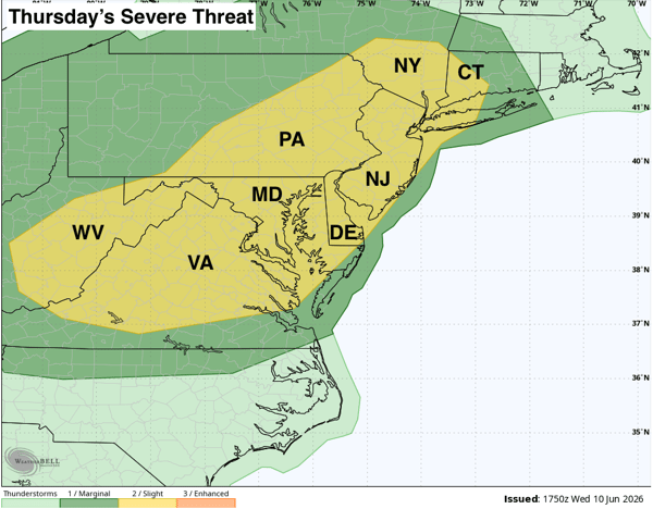
Thursday & Friday Severe Threat for the Mid Atlantic and Northeast
The severe weather doesn't stop in the Midwest. The Northeast will need to prepare for severe weather as well, especially on Thursday and Friday. Thursday's threat will be mostly for damaging winds storms develop in the afternoon:
This storm threat is being fueled by some of the warmest temperatures of the summer. Below are the forecast highs for Thursday with many locations getting well into the 90s and a few record highs possible:
<Forecast graphic previously posted here is no longer available>
Friday's severe threat for the region will encompass a slightly larger area and will include the potential for damaging winds and large hail:
<Forecast graphic previously posted here is no longer available>
It is also being fueled by very warm temperatures with even more record highs possible on Friday:
<Forecast graphic previously posted here is no longer available>
Florida Rainy Season Ramps Back Up
For the past week, the daily thunderstorm activity so common in the summer months has been pretty minimal across the sunshine state. In fact, the entire state experienced well below average rainfall from June 3 through June 10th:
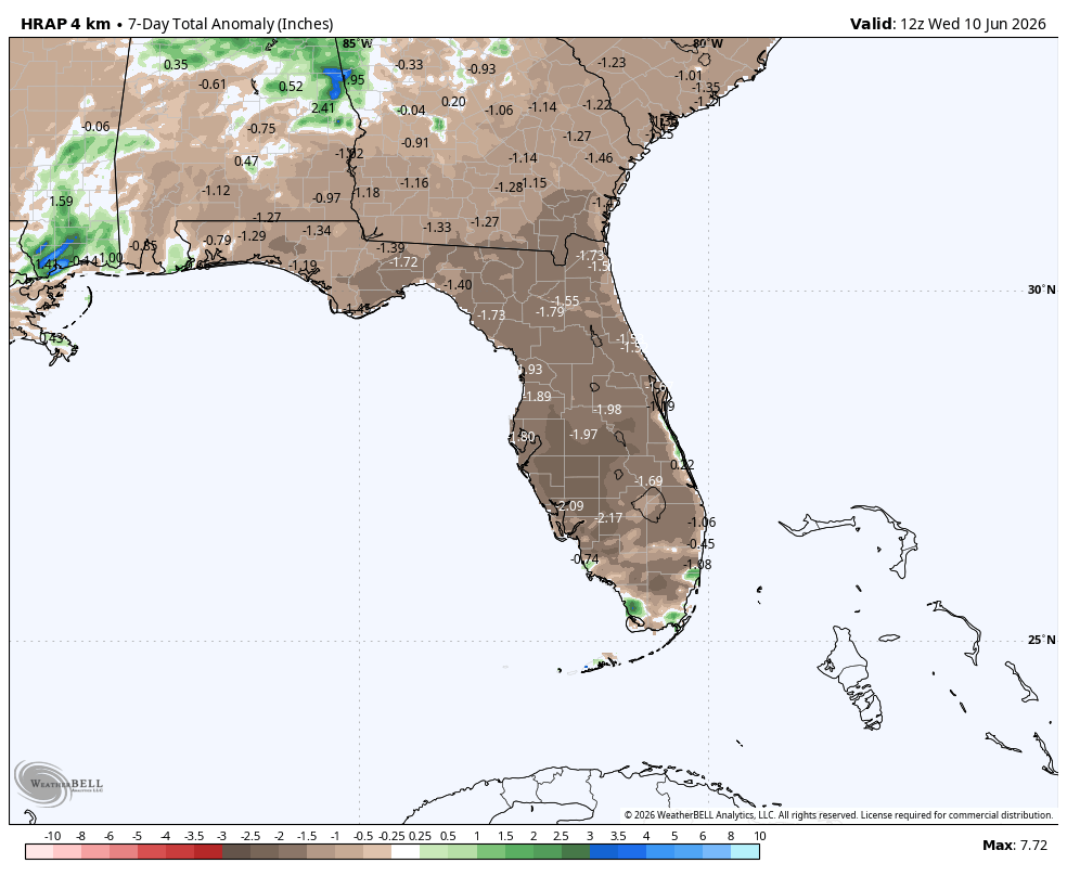
Because of this recent dry spell, we don't anticipate any improvements in tomorrow's drought monitor update. The good news is the next week should provide an uptick in storm activity and more widespread rain for the state, especially the Panhandle and northern parts. The image below shows the rainfall departure from average from June 11 - 18:
<Forecast graphic previously posted here is no longer available>
The return of a more typical summertime pattern will mean daily rounds of sea breeze thunderstorms, especially during the afternoon and evening hours. While not every location will see rain each day, coverage should be much greater than what Florida experienced during the past week.
Watching the Gulf for Tropical Development
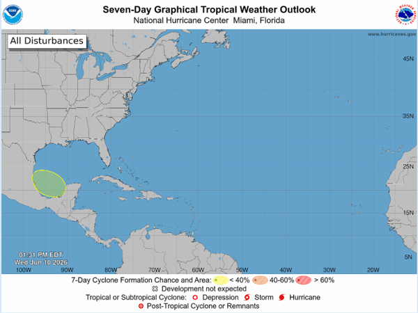
In last week's On the Radar blog we discussed the potential for tropical development in the Gulf. Today, the National Hurricane Center issued their first area to watch of the season, with a 10% chance of development circled in the Bay of Campeche:
Last week, we shared the ECMWF Ensembles showing both the potential for this highlighted area and for something further north in the Gulf. Now, it looks like just the area highlighted above will have a chance for development:
<Forecast graphic previously posted here is no longer available>
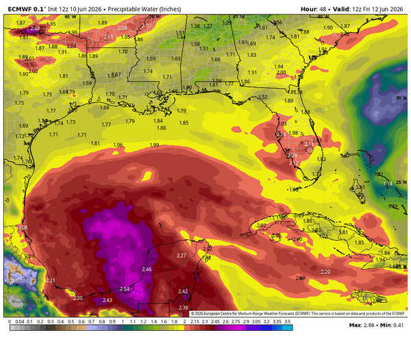
This is right where development is expected this time of year. Environmental conditions and the system's proximity to land should limit any significant strengthening before it moves inland. It could bring some heavy rainfall to Mexico and even provide some enhanced moisture across the Southern US next week. This is illustrated nicely by the animated precipitable water from Friday June 12 through Monday June 15:
Looking Ahead
Severe weather across the Midwest, Great Lakes, Mid-Atlantic, and Northeast remains the most immediate concern through Friday. Florida's rainy season is also returning, bringing more widespread rainfall and daily thunderstorm activity back to the state. Meanwhile, the Bay of Campeche will be worth watching this weekend, although any tropical development currently appears likely to remain limited.
We'll continue monitoring all three weather stories and provide updates as conditions evolve.
Will severe weather continue through the weekend?
Yes. Multiple rounds of severe thunderstorms are expected from the Midwest into the Northeast through Friday, with damaging winds, large hail, and tornadoes possible.
Why is Florida becoming wetter again?
Florida's typical summer weather pattern is returning, allowing daily sea breeze thunderstorms to become more widespread after a recent dry period.
Is tropical development expected in the Gulf?
The National Hurricane Center is monitoring an area in the Bay of Campeche with a low chance of development later this weekend.
Could the Gulf system impact the United States?
Current forecasts suggest any development would likely remain near Mexico, though increased tropical moisture could eventually reach parts of the southern United States.
What is the biggest weather threat this week?
The most significant threat is the ongoing severe weather outbreak affecting portions of the Midwest, Great Lakes, Mid-Atlantic, and Northeast through the end of the workweek.
Weatherstem
Real-time weather monitoring for the organizations that can't afford to guess.
Professional hardware, live HD camera, automated alerts, and software — installed and managed for you. 900+ stations deployed nationwide across emergency management, athletics, and commercial operations.
Book a Free Demo

