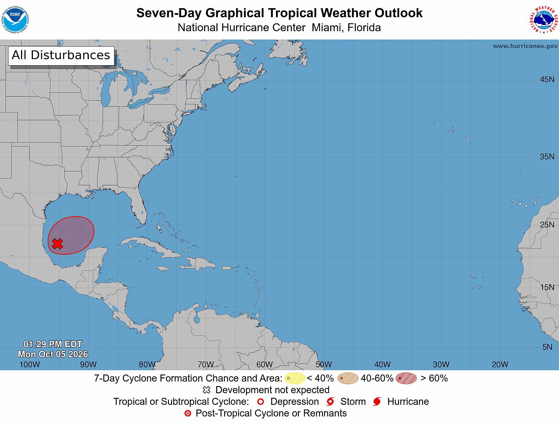
Invest 92L is now Tropical Depression Nine (TD9), and the system is likely to become a hurricane before landfall this weekend. The National Hurricane Center (NHC) initiated advisories on the system at 5 p.m. Tuesday, October 6, after it had been designated Invest 92L earlier in the week. The forecast has become clearer since yesterday, but there are still several question marks surrounding the storm's eventual track and intensity. Let's discuss what has changed since yesterday's update.
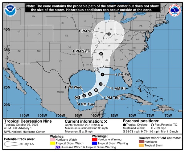
Note: Some of the forecast graphics in this update still identify the system as Invest 92L. These graphics were produced before the National Hurricane Center designated it as Tropical Depression Nine. They are referring to the same system.
Where Will TD9 Track?
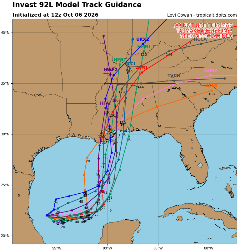
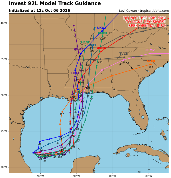
We are getting a clearer picture of the track that TD9 will likely take. After spending the next couple of days slowly moving east through the Southwest Gulf, it should turn to the northeast and eventually toward the north. The spaghetti model tracks show this nicely, with potential landfall locations ranging from Southeast Louisiana to the western Florida Panhandle:
 This general movement is also predicted by the Google DeepMind model, but it shows a slightly farther east track, with landfall somewhere along the western Florida Panhandle:
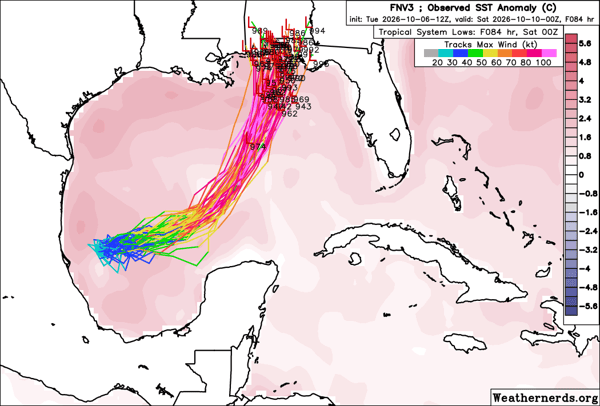
Still, the caveat remains that we are very early in the forecast. While TD9 has now developed, track forecasts can change considerably and uncertainty will remain higher than normal.
How Strong Will TD9 Get?
In one of the more significant updates from yesterday's outlook, many of our forecast models are now showing TD9 strengthening into a Category 1 hurricane or stronger before landfall this weekend:
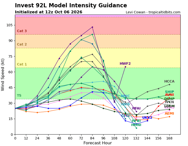 In yesterday's blog, we discussed the potential for a stronger storm if the path keeps it away from the strong shear across the northern Gulf Coast for longer. That scenario is becoming more likely in today's guidance. In fact, in the NHC's first forecast, they are calling for the storm to peak at 100 mph, which would make it a Category 2 hurricane.
What Will the Biggest Impacts from TD9 Be?
While it is still too early for exact details on potential impacts, there are several threats worth discussing.
Strong Winds
It goes without saying that the stronger the storm becomes, the greater the potential for damaging winds along the coast and farther inland. The right side of a storm typically experiences the strongest winds, making the exact landfall location important for determining potential wind impacts.
Storm Surge, Waves, and Rip Currents
Much like the winds, the biggest surge occurs on the right side of a storm. Areas along the northern Gulf Coast from Louisiana to the Florida Panhandle could experience storm surge, with the greatest impacts dependent on the eventual track, intensity, and size of the storm. Rip current risk will also increase in the days ahead as the system churns up the water in the Gulf. Wave heights will increase as the storm intensifies, and large waves can reach the coast well before the storm makes landfall. Below is the wave height forecast for Friday, Oct 9th at 8 a.m.:
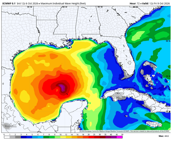 Wave heights over 10 feet are already approaching the northern Gulf Coast and even parts of the Texas coast.
Severe Weather Threat
As with most landfall tropical systems, there is typically an increased risk for tornadoes in the right front quadrant of the storm. This means areas just to the north and east of the storm could see an increased tornado threat. In fact, the Storm Prediction Center has already outlined a potential area for severe weather for Saturday:
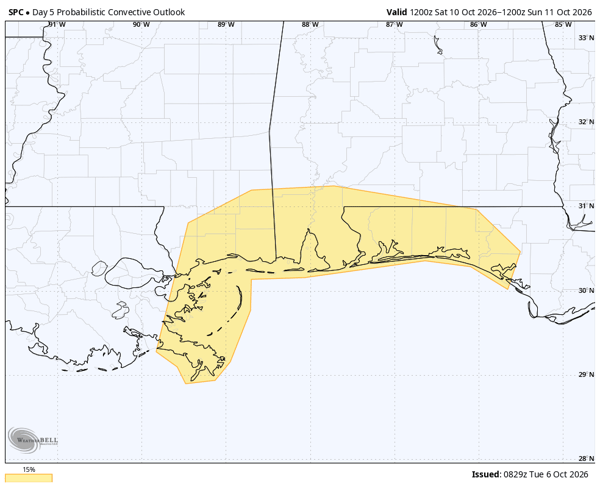 This threat area includes the Mississippi coast, Alabama coast, and the western Florida Panhandle. Tropical tornadoes are often quick to develop and dissipate, making them particularly difficult to detect and warn for.
Heavy Rain and Flooding
Perhaps the most overlooked but often most dangerous impact is from heavy rain and fresh water flooding. This is the one aspect of TD9 that we can have the most confidence in at this point. Below is the 72-hour Euro Ensemble rain totals from 8 a.m. on Friday October 9 through 8 a.m. on Monday October 12:
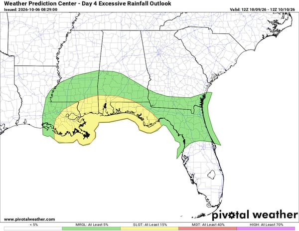
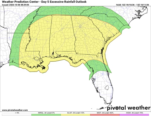
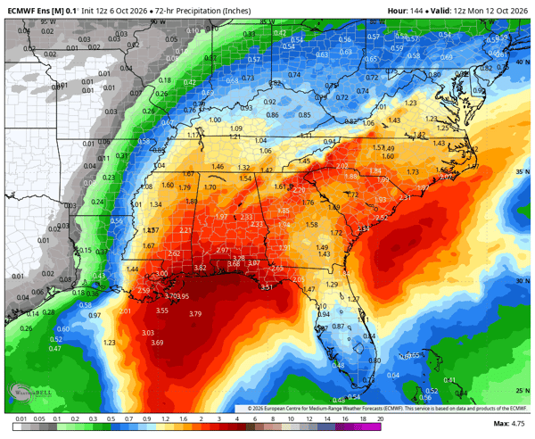 That's a strong signal for more than 3 inches of rain across portions of the Gulf Coast and the Southeast. In fact, the Weather Prediction Center has already outlined an area for a slight risk, or level two out four, for flooding for both Friday and Saturday:
What to Watch This Week
There is still uncertainty surrounding the exact track and intensity of TD9, but the overall forecast is becoming clearer. The NHC is now forecasting TD9 to become a hurricane before landfall, while heavy rain and flooding appear to be the most certain impacts at this point. Strong winds, storm surge, waves, rip currents, and tornadoes will also need to be monitored as the system develops.
We will continue to monitor TD9 as it develops and provide updates as the forecast becomes more certain.
1. What is Tropical Depression Nine?
Tropical Depression Nine (TD9) is the system that was previously designated Invest 92L. It is currently moving through the Gulf of Mexico and is forecast to strengthen before making landfall along the northern Gulf Coast.
2. Is Tropical Depression Nine expected to become a hurricane?
Yes. The National Hurricane Center is forecasting Tropical Depression Nine to strengthen into a hurricane before landfall this weekend, with the potential for significant impacts along the northern Gulf Coast.
3. Where is Tropical Depression Nine expected to make landfall?
The exact landfall location remains uncertain. Current forecast guidance generally shows the system moving northeast toward the northern Gulf Coast, with potential landfall locations ranging from southeast Louisiana to the western Florida Panhandle.
4. What impacts could Tropical Depression Nine bring?
Potential impacts include strong winds, storm surge, large waves, rip currents, tornadoes, heavy rainfall, and freshwater flooding. The exact impacts will depend on the storm's eventual track, intensity, and size.
5. Will Tropical Depression Nine bring heavy rain to the Southeast?
Yes. Heavy rainfall is one of the more consistent signals in the forecast. Portions of the Gulf Coast and Southeast could receive several inches of rain, with localized flooding possible.
6. Why do some forecast graphics still show Invest 92L?
Some forecast graphics were produced before the National Hurricane Center designated the system as Tropical Depression Nine. Invest 92L and Tropical Depression Nine refer to the same system.
7. How confident is the forecast for Tropical Depression Nine?
The overall forecast is becoming clearer, but uncertainty remains regarding the exact track and intensity. Forecast confidence should increase as the system develops and additional observations become available.
Weatherstem
Real-time weather monitoring for the organizations that can't afford to guess.
Professional hardware, live HD camera, automated alerts, and software — installed and managed for you. 900+ stations deployed nationwide across emergency management, athletics, and commercial operations.
Book a Free Demo