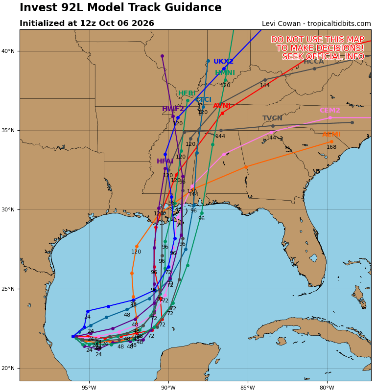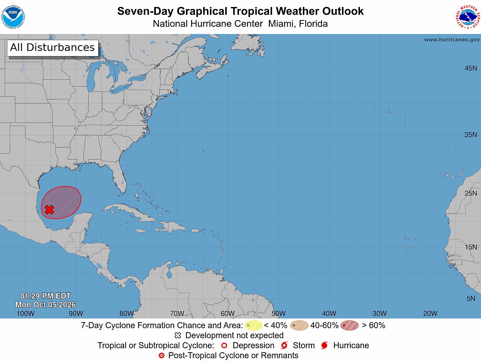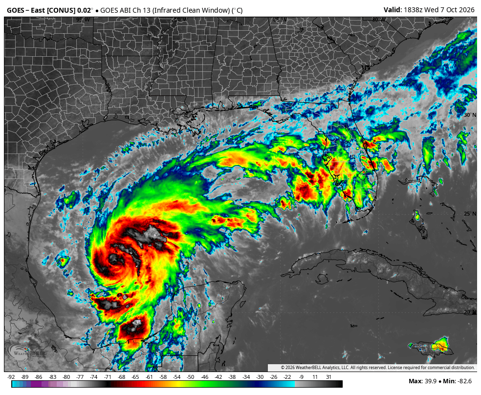
Tropical Storm Isaias (formerly Invest 92L and Tropical Depression Nine) formed earlier Wednesday in the southwest Gulf. The official forecast calls for Isaias to strengthen into a hurricane by Thursday, with some guidance suggesting it could become a major hurricane. The forecast continues to be fine-tuned, but areas along the northern Gulf Coast from New Orleans to Panama City should be prepared for damaging winds, dangerous storm surge, and heavy rain.
For detailed information for your exact location, check out our Isaias tracker at this link: https://isaias.weatherstem.com/me
Where Will Isaias Track?
The overall track forecast has changed little since yesterday's update. Isaias is still expected to make landfall somewhere along the northern Gulf coast between New Orleans and Destin, FL. The models are in good agreement on this track, with a cluster of landfall solutions on the Mississippi and Alabama coasts, or the far western Florida Panhandle.
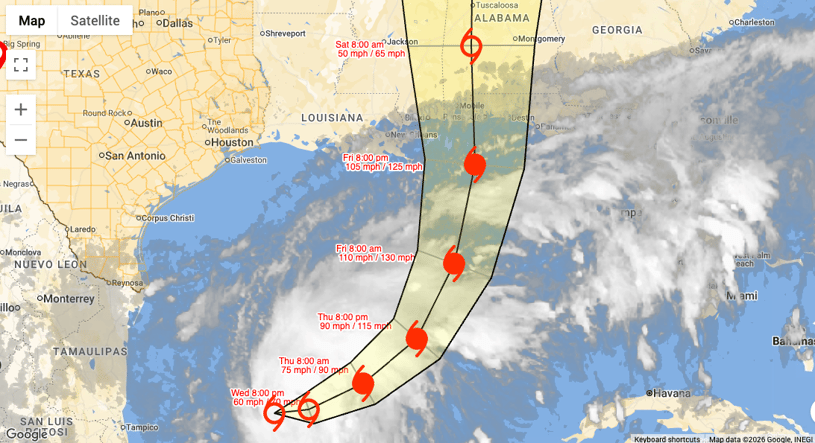
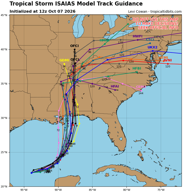 It is important not to focus on the exact landfall location as impacts from a landfalling hurricane extend far away from the center of the storm. The strongest winds, highest surge, and biggest tornado threat are typically on the right side of the storm. The official NHC track below follows this guidance:
How Strong Will Isaias Get?
Most guidance now has Isaias getting to hurricane strength and the official NHC forecast is calling for a peak intensity of 110 mph.
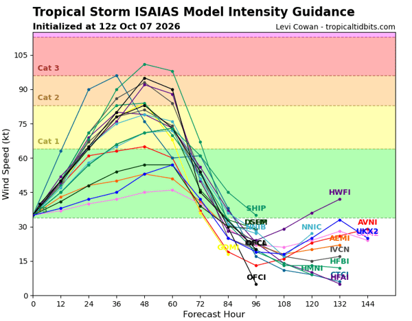 The biggest question mark is what its intensity will be at landfall. The storm should begin to weaken as wind shear increases, but it is also expected to grow in size. This means that even though winds may be weaker, the area impacted by the strongest winds will increase.
When Will Isaias Make Landfall?
While exact landfall timing is still uncertain, the most likely time frame right now is sometime late Friday night into Saturday morning. Conditions along the northern Gulf Coast will deteriorate throughout the day on Friday with the most significant impacts occurring during the overnight hours from Friday into Saturday. The image below is a good approximation of when tropical-storm-force winds will arrive:
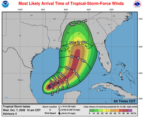 By Friday evening at 8 p.m. CDT, conditions will be deteriorating along the northern Gulf Coast, with tropical-storm-force winds spreading across the region. Organizations and communities along the coast will need to account for deteriorating conditions as tropical-storm-force winds arrive.
What Will the Biggest Impacts Be from Isaias?
Damaging Winds
We mentioned yesterday that the most damaging wind threat will depend on the exact landfall location. However, as we said earlier, many impacts, including wind, will extend outside of the cone. The graphic below provides a good representation of that:
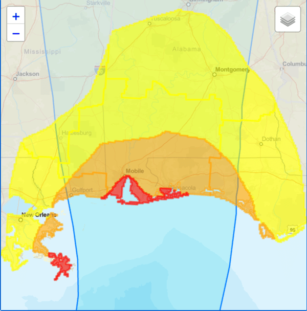
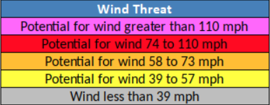 The greatest potential for hurricane-force winds is along the Alabama coast and far western Florida Panhandle (area in red in the above image). The yellow area above shows the locations that could experience tropical-storm-force winds and that includes New Orleans to just west of Tallahassee, FL and all the way inland to Tuscaloosa.
Storm Surge, Waves, and Rip Currents
Dangerous storm surge will occur well outside of the path of the storm with the highest amounts predicted just to the east of where the storm makes landfall. The official forecast from the NHC is below:
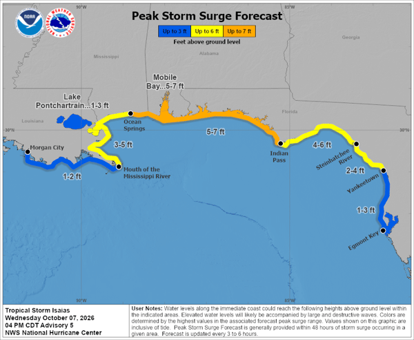
Five to seven feet of storm surge is likely from Ocean Springs, MS all the way to Indian Pass, FL. Another way to visualize the potential surge impacts is with the forecast path and potential surge:
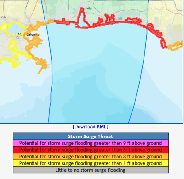 Most of the Mississippi coast, the entire Alabama coast, and the Panhandle coast all the way to Franklin County have the potential for storm surge greater than 6 feet (red area above).
In addition to the surge, large waves will increase as the storm approaches the coast. Wave heights over 30 feet are possible as the storm moves north. The animation below shows the increasing waves:
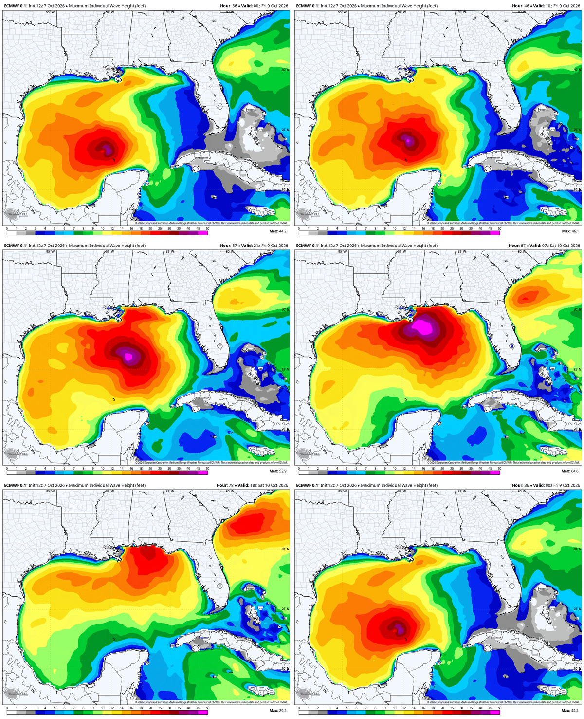 The combination of surge and these large waves will cause dangerous conditions on the beaches. These conditions will also increase the risk of rip currents.
Tornado Threat
A significant tornado threat is possible east of where Isaias makes landfall. The Storm Prediction Center (SPC) has already outlined an area for possible severe weather on Friday, Oct 9 and Saturday, Oct 10:
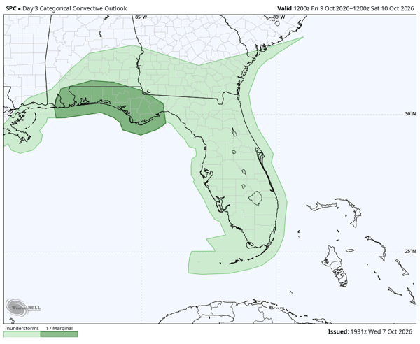
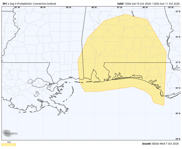
We mentioned yesterday how difficult it can be to warn for tornadoes produced by tropical storms. They can develop and dissipate quickly and are typically short-lived, although that isn't always the case.
Heavy Rain and Flooding
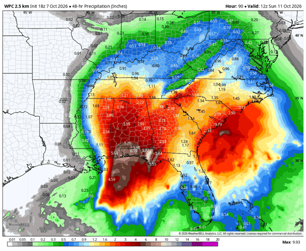
Isaias is expected to move quickly inland, so a prolonged heavy rain threat is not anticipated. Still, heavy rain will fall across the Southeast and flooding will be possible, especially in areas across the Panhandle that have already received several inches of rain this month. Five to six inches of rain are likely across the Panhandle, with widespread two to three inches into Alabama and Georgia:
 One change from yesterday's update is that the western Panhandle and much of the Mobile Bay area have been upgraded to a Level 3 out of 5 risk for excessive rainfall:
.png?width=600&height=464&name=wpc_excessive_rainfall_day3.us_se%20(1).png)
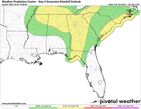
By Saturday, that threat spreads across the Southeast:
What to Watch
Isaias is expected to strengthen into a hurricane before reaching the northern Gulf Coast, with the greatest impacts likely from damaging winds, storm surge, tornadoes, and heavy rain. While the exact landfall location remains uncertain, the overall forecast has become more consistent, and impacts will extend well beyond the center of the storm.
We will continue to monitor Isaias as it approaches the Gulf Coast and provide updates as the forecast evolves.
What is Tropical Storm Isaias?
Tropical Storm Isaias is the system previously designated Invest 92L and Tropical Depression Nine. The storm formed in the southwest Gulf of Mexico and is forecast to strengthen into a hurricane before reaching the northern Gulf Coast.
Is Tropical Storm Isaias expected to become a hurricane?
Yes. The National Hurricane Center is forecasting Isaias to strengthen into a hurricane before reaching the Gulf Coast, with further strengthening possible before landfall.
Where is Tropical Storm Isaias expected to make landfall?
The exact landfall location remains uncertain, but current forecast guidance generally points toward the northern Gulf Coast from the New Orleans area toward the Florida Panhandle, with many model solutions clustered across Mississippi, Alabama, and the western Florida Panhandle.
When will Tropical Storm Isaias make landfall?
The most likely timeframe for landfall is late Friday night into Saturday morning. Tropical-storm-force winds are expected to reach portions of the northern Gulf Coast before the center of the storm arrives.
What impacts will Tropical Storm Isaias bring?
Potential impacts include hurricane-force and tropical-storm-force winds, storm surge, large waves, rip currents, tornadoes, heavy rainfall, and flooding. Impacts will extend well beyond the center of the storm.
How much rain will Tropical Storm Isaias bring?
Several inches of rain are possible across portions of the Florida Panhandle and Southeast. The heaviest rainfall is expected across the Panhandle, with additional rainfall extending into Alabama and Georgia.
Weatherstem
Real-time weather monitoring for the organizations that can't afford to guess.
Professional hardware, live HD camera, automated alerts, and software — installed and managed for you. 900+ stations deployed nationwide across emergency management, athletics, and commercial operations.
Book a Free Demo